The Minnesota Runoff Risk Advisory Forecast (RRAF) system is a tool developed by the Minnesota Department of Agriculture and the National Weather Service (NWS). It is designed to help farmers and commercial applicators determine the best time to apply manure to reduce the probability of off target movement of valuable nutrients and to protect water resources. The RRAF is a decision support tool based on real-time NWS weather/hydrologic forecast models to support short-term field management decisions for manure applications.
The RRAF takes into account estimated soil moisture content, soil temperatures, past precipitation along with forecasted precipitation and temperatures to predict the likelihood of runoff events in coming days. Farmers and commercial applicators use an interactive map to locate their field and find the forecasted risk. Users can also sign up for email or text messages for their county that alerts them if a severe runoff risk is predicted for that day. The home page for the project is at www.mda.state.mn.us/rraf.
“By providing this information, we hope to give our farmers and commercial manure applicators the tools they need to make well-informed decisions,” said Agriculture Commissioner Dave Frederickson. “By being able to better predict times of high runoff risk, we can decrease the potential loss of manure to our waterways and increase farm productivity by saving nutrients on the land. It is a win-win situation based on an easy-to-use tool.”
Runoff risk is grouped into four categories on the map: No event (clear), Low (light yellow), Moderate (orange) and Severe (red). When the risk is Moderate or Severe, it is recommended that the applicator evaluate the situation to determine if there are other locations or later dates when the application could take place.
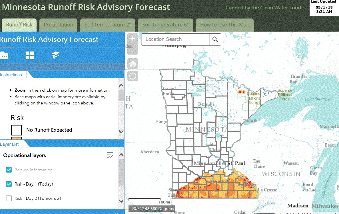
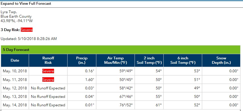
Using the interactive map, the user can zoom in and pull up a table that provides further information on the forecast including the runoff risk, precipitation and soil temperature all in one summary. Locations can also be bookmarked to allow users to quickly return to the same location on subsequent visits to the website. For example, below is a screenshot of the data table for the forecasted risk for Lyra Township in Blue Earth County on May 10, 2018. The multi-day risk is Severe.
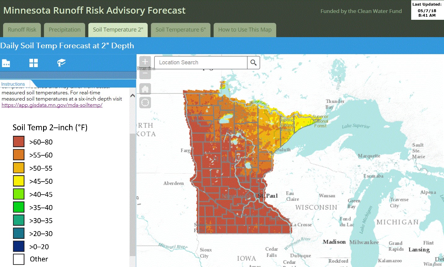
The RRAF website also provides statewide estimated daily 2” soil depth temperatures which can be useful at planting time, daily 6” soil depth temperatures which are helpful when determining fall fertilizer application in appropriate areas and five days’ worth of daily precipitation forecasts.
The RRAF is part of a regional Runoff Risk Advisory Forecast project including the states of Wisconsin, Michigan, Minnesota and Ohio. The project was made possible with Clean Water Land and Legacy Amendment funds in Minnesota and through Great Lakes Restoration Initiative funds obtained by the National Weather Service.
- Minnesota’s Runoff Risk Advisory Forecast website - May 11, 2018