By Kevin Kuehner – Root River Field to Stream Partnership – Minnesota Department of Agriculture, August 2018
Small areas of a field or landscape can contribute a disproportionate amount of sediment and nutrient loss. These locations are often referred to as high risk or critical source areas. In some studies, it is suggested that 80% of the measured loss in a watershed can be associated with just 20% of the land area. Precisely targeting these areas could go a long way in addressing water quality goals in a cost-effective manner. One example of a critical source area is an ephemeral gully. Ephemeral gullies are defined as small, visible channels eroded by concentrated flow that are filled by normal tillage, only to form again in the same location with additional runoff. Edge of field monitoring associated with the Root River Field to Stream Partnership has provided a unique opportunity to measure loss associated with this type of erosion.
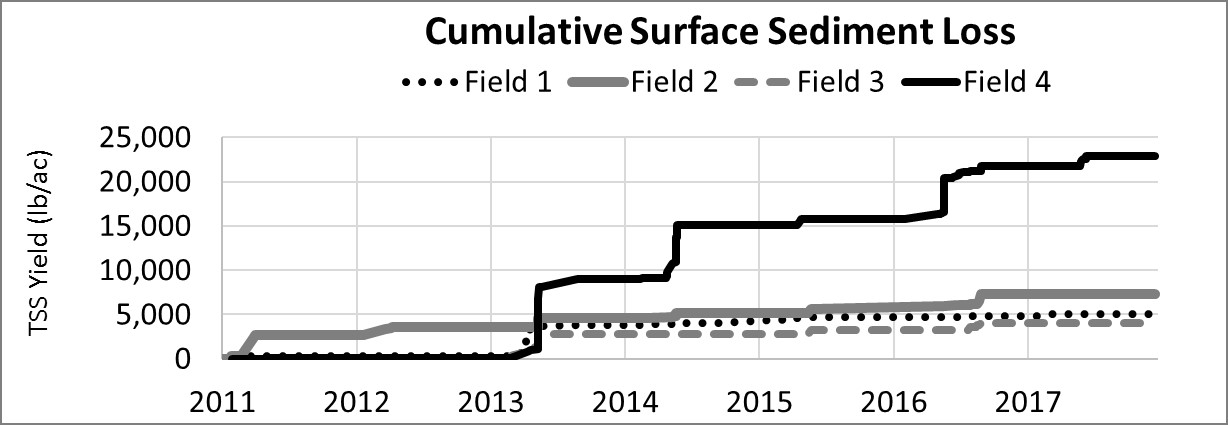
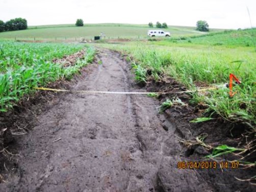
Figure 1 shows the cumulative sediment loss (delivery off the field) measured in surface runoff over a seven-year period (2011-2017) from four conventional tilled fields in southeast Minnesota. Fields 1, 2 and 3 had cumulative sediment loss rates between 4,000 lb/ac and 7,300 lb/ac. For perspective, typical rates of soil formation range from 3,400 lb/ac to 7,000 lb/ac every seven years and runoff monitoring conducted by MN/WI Discovery Farms have shown that no-till operations typically lose less than 1,500 lb/ac over a seven-year period. Field 4 lost 23,000 lb/ac of soil which equates to three to seven times faster than the soil formation rate. When compared to field 2, this site had three times more soil loss (two times more phosphorus and three times more nitrogen) in surface runoff. Field 2 is a suitable comparison to field 4 since it has similar soils, slope and cropping system. During the first three years, field 4 had virtually no sediment loss. However, in 2013 the tables had turned. A series of rainfall events in April, May and June caused a gully to form along the outside edge of an existing grassed waterway. Once this gully had formed, it acted like a conveyer belt, easily moving excessive amounts of soil during subsequent rainfall events (Figure 2). With each tillage pass in the spring and fall, the gully was filled in, only to be exposed during the next large rain event.
The farm operator of field 4 has recently rehabilitated this particular grassed waterway along with 17,000 additional feet of waterways on his farm and considering additional reduced tillage practices. The waterway channels were reshaped with a bulldozer and re-seeded with sod-forming, cool season grasses. Monitoring will continue on this field to measure the increased performance of the grassed waterway rehabilitation.
- New Life for Old Flood Structure - October 30, 2018
- Dialing in profitable nitrogen rate and timing practices - October 10, 2018
- Testing Nitrogen Rate BMP Recommendations - September 27, 2018